


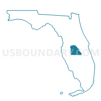
512-Voting District, Polk County, Florida
About
Outline

Summary
| Unique Area Identifier | 558912 |
| Name | 512-Voting District |
| County | Polk County |
| State | Florida |
| Area (square miles) | 138.16 |
| Land Area (square miles) | 107.12 |
| Water Area (square miles) | 31.05 |
| % of Land Area | 77.53 |
| % of Water Area | 22.47 |
| Latitude of the Internal Point | 27.74590630 |
| Longtitude of the Internal Point | -81.97829100 |
Maps


Graphs
Select a template below for downloading or customizing gragh for 512-Voting District, Polk County, Florida


Neighbors
Neighoring Voting District (by Name) Neighboring Voting District on the Map
- 1-Voting District, Hardee County, FL
- 247-Voting District (Mulberry), Polk County, FL
- 4-Voting District, Manatee County, FL
- 507-Voting District (Bartow), Polk County, FL
- 513-Voting District (Homeland), Polk County, FL
- 516-Voting District, Polk County, FL
- 517-Voting District, Polk County, FL
- 705-Voting District, Hillsborough County, FL
- 706-Voting District, Hillsborough County, FL
- 917-Voting District, Hillsborough County, FL
Top 10 Neighboring County Subdivision (by Population) Neighboring County Subdivision on the Map
- Wimauma-Riverview CCD, Hillsborough County, FL (123,563)
- Bartow CCD, Polk County, FL (61,093)
- Parrish CCD, Manatee County, FL (22,183)
- Bowling Green CCD, Hardee County, FL (5,069)
Top 10 Neighboring Place (by Population) Neighboring Place on the Map
Top 10 Neighboring Unified School District (by Population) Neighboring Unified School District on the Map
- Hillsborough County School District, FL (1,229,226)
- Polk County School District, FL (602,095)
- Manatee County School District, FL (322,833)
- Hardee County School District, FL (27,731)
Top 10 Neighboring State Legislative District Lower Chamber (by Population) Neighboring State Legislative District Lower Chamber on the Map
- State House District 67, FL (241,034)
- State House District 62, FL (162,165)
- State House District 66, FL (162,026)
- State House District 63, FL (156,183)
Top 10 Neighboring State Legislative District Upper Chamber (by Population) Neighboring State Legislative District Upper Chamber on the Map
- State Senate District 10, FL (565,921)
- State Senate District 15, FL (560,770)
- State Senate District 21, FL (529,870)
- State Senate District 17, FL (456,960)
Top 10 Neighboring 111th Congressional District (by Population) Neighboring 111th Congressional District on the Map
- Congressional District 12, FL (842,199)
- Congressional District 13, FL (757,805)
- Congressional District 9, FL (753,549)
Top 10 Neighboring Census Tract (by Population) Neighboring Census Tract on the Map
- Census Tract 139.03, Hillsborough County, FL (3,419)
- Census Tract 19.14, Manatee County, FL (2,899)
- Census Tract 148.02, Polk County, FL (2,857)
- Census Tract 160.03, Polk County, FL (2,551)
- Census Tract 159, Polk County, FL (2,476)
- Census Tract 161, Polk County, FL (1,258)
- Census Tract 9702.02, Hardee County, FL (959)
Top 10 Neighboring 5-Digit ZIP Code Tabulation Area (by Population) Neighboring 5-Digit ZIP Code Tabulation Area on the Map
- 33830, FL (27,542)
- 33860, FL (22,886)
- 33547, FL (19,813)
- 34219, FL (17,135)
- 33841, FL (8,722)
- 33834, FL (7,448)